February 16, 2026
Local News / Los Angeles / Dangerous Storm Heads to California, 43M on Flood Watch

Dangerous Storm Heads to California, 43M on Flood Watch

0 20

A dangerous storm targets California, placing 43M people on alert for potential flooding. Stay updated on safety and emergency responses.

Dangerous Storm

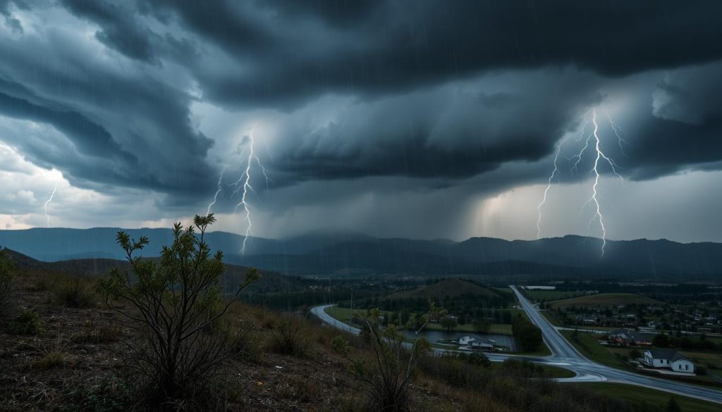
California is getting ready for a dangerous storm that could last for days. About 43 million people are under flood watch. The National Weather Service in Los Angeles has issued a severe weather alert for the coast to inland valleys.

Forecasters say this storm feels like a natural disaster. An atmospheric river is bringing rain, and a dip in the jet stream is letting Pacific moisture flow into the West Coast.

This isn’t just one storm. A series of storms is coming, bringing heavy rain, high winds, and strong waves. There’s also a chance for severe storms and tornadoes.

Recent flooding shows how quickly things can change. In Mission Valley, the San Diego River overflowed, leaving a traffic sign underwater on Jan. 1, 2026.

For more on the storm’s impact, check out this storm update. Warnings are expanding, and travel plans are getting harder to keep up with.

Key Takeaways

  • California faces a dangerous storm that could bring several days of heavy rain and damaging winds.
  • Roughly 43 million people are under flood watch coverage as flash flooding becomes a top concern.
  • The National Weather Service in Los Angeles is calling it a “very significant and dangerous” threat.
  • An atmospheric river and a jet stream dip are funneling deep Pacific moisture into the West Coast.
  • High surf, strong waves, and severe weather alerts indicate hazardous travel and rapidly changing conditions.
  • Mission Valley flooding in San Diego is a reminder of how quickly roads and rivers can overwhelm low-lying areas.

Dangerous Storm threatens California as an atmospheric river fuels severe weather

California is preparing for a major storm. An atmospheric river is coming with a new storm. Forecasters expect the weather to change quickly, so be prepared.

Getting ready for the storm starts with timing. Knowing when the rain and wind will hit is key. Simple steps, such as charging devices and securing outdoor items, can help.

National Weather Service Los Angeles issues “very significant and dangerous” storm alerts

The National Weather Service in Los Angeles warns of a “very significant and dangerous” storm. They say there’s a high risk of flash flooding and even tornadoes early in the week.

Conditions can change fast, from flooded roads to airport issues. This is seen in Southern California flood watches and closures. This underscores the need for emergency plans, particularly in low-lying areas.

Jet stream dip opens the door for abundant Pacific moisture into the West Coast

A dip in the jet stream is creating a path for storms. These storms can bring deep-ocean moisture to California and the West Coast.

This path can make rain more efficient. It keeps raining coming onshore. When the forecast changes, storm safety tips become more important.

What to expect: high winds, strong waves, heavy rain, and a sneaky severe weather setup

Monday’s rain will bring a severe-weather setup. The FOX Forecast Center has a level 1/5 severe risk for Southern California. This is a low-end category, but it can cause damage.

  • High winds can bring down branches and cause power issues
  • Strong waves and rough surf along exposed beaches
  • Heavy rain that raises the flash flood threat in minutes
  • Brief severe storms that may form quickly within heavier bands

Emergency plans should include quick warnings, not just all-day rain. Delaying coastal visits when surf and rip currents build is also wise.

Where impacts concentrate: Los Angeles basin, coastal areas, and vulnerable burn-scar zones

The severe threat will hit the Los Angeles basin hard. Storms can also spin up waterspouts that come ashore. If these track inland, tornadoes are possible.

The FOX Forecast Center notes Los Angeles County has had 49 tornadoes, with only 9 in winter. This makes the region more vulnerable.

Coastal areas and burn-scar zones will be hardest hit. Runoff can quickly become debris flows. A recent overview of the multi-storm timeline and mountain snow levels is outlined in the latest triple-storm forecast.

Storm safety tips focus on being aware. Watch alerts, avoid flooded intersections, and be ready to move if needed. Emergency plans should be simple and ready before the storm hits.

Flood watch details, rainfall totals, and the highest-risk locations for flash flooding

A Flood Watch covers much of Los Angeles County. The terrain and recent fires increase the risk of heavy rain. Climate change adds to the risk.

Now is the time to check your disaster plan. Focus on preventing storm damage where possible.

A detailed, informative meeting room setting focused on a disaster response plan for flooding. In the foreground, a large table covered with maps, charts, and colorful highlighters showing rainfall totals and risk areas illustrated with red and yellow markers. Professional individuals in business attire, including a diverse group of emergency responders and planners, are engaged in discussion, pointing to the maps, and taking notes. The middle ground features a whiteboard filled with strategic diagrams on how to prepare for flash flooding. In the background, a large window displays dark, ominous storm clouds gathering over a cityscape, hinting at the dangerous storm approaching California. The atmosphere is tense yet focused, with bright fluorescent lighting adding a sense of urgency to the scene. Use a wide lens angle to capture the full scope of the planning session.

Rainfall forecast: 3–5 inches for Southern California, with localized higher totals possible

Mountain areas might see 3–5 inches of rain. Coastal areas could get 1–2 inches. Some areas may receive even more, causing creeks to overflow.

Rainfall could range from 0.5 to 0.75 inches per hour. In some cases, it could be as high as 1 inch per hour. This could overwhelm storm drains and cause water to run off hillsides quickly.

Rapid-response flooding: creeks and rivers rising quickly, urban flooding possible around Los Angeles

Flooding can occur rapidly when channels rise quickly. In Los Angeles, flooding can occur in low spots. This includes underpasses and areas where debris blocks storm grates.

In Malibu, roads may close for several days. This shows how a single blocked road can disrupt travel and emergency access. Clearing leaves from storm drains and avoiding low spots can help prevent damage.

Flood risk timing: level 2/4 flood risk Monday through Tuesday; hourly rain rates up to 0.5.”

The heaviest rain is expected between 6:00 a.m. and 6:00 p.m. PT. The Los Angeles Metro area faces a high flash flood risk after 10:00 a.m. PT. This risk will last into early Tuesday.

The FOX Forecast Center says the weather will stay unsettled after Monday. More storms could come through midweek. This keeps the soil wet, and even moderate rain can cause more flooding. For updates, check the ongoing storm updates.

Mudslides and evacuations: saturated soils, dangerous debris flows, and warnings in the most vulnerable zones

As hillsides get wet, the risk of debris flows increases. This is true near burn scars where water repels from the soil. Evacuation warnings are in place for some areas.

In these zones, a disaster plan should include fast-moving water and sudden road closures. Climate change makes these areas more vulnerable to flooding.

Know your flood terminology: what Flood Watches, Warnings, and Emergencies really mean

  • Flood Watch: Conditions are favorable for flooding; people should monitor alerts and be ready to act.
  • Flood Warning: Flooding is happening or imminent; protective action is needed immediately.
  • Flash Flood Warning: Rapid, life-threatening flooding is occurring or imminent, often from intense rainfall.
  • Flood Emergency: Rare wording used for an extreme, life-threatening flood event with severe impacts expected or ongoing.

These terms are important, like when water blocks a road. The National Weather Service provides guidance on flash flood threats. For more information, visit flash flood threat level guidance.

Knowing where to go during severe weather is key. The more you practice, the easier it is to act quickly when needed.

Conclusion

A dangerous storm is heading for California, fueled by an atmospheric river and a jet stream dip. It will bring heavy rain, strong winds, and high waves. The setup can also increase rainfall rates, as shown in climate and severe-storm research.

Alerts warn of flash flooding, rising creeks and rivers, and urban flooding in Los Angeles. The Los Angeles basin also faces a low-end tornado risk, mainly from waterspouts. People should prepare for downed trees, power outages, and slippery roads before the worst rain hits.

Expect 3–5 inches of rain in Southern California, with higher totals in some areas. There’s a level 2/4 flood risk from Monday to Tuesday. Hourly rainfall rates could reach 0.5 inches, causing drains to overflow and streets to flood.

The threat may not stop after the first storm, as more systems could arrive through midweek. This keeps soils wet and raises mudslide risks near burn scars. Stay updated with NWS Los Angeles, follow evacuation orders, and understand the difference between Flood Watch, Warning, and Emergency.

For more on storm safety, including injuries, heat, and flood dangers, check out Deadly Storms and health risks. It’s a reminder of the dangers of underestimating water and wind.

FAQ

Why are 43 million people in California under a Flood Watch for this dangerous multi-day storm?

A dangerous storm associated with an atmospheric river is expected to bring heavy rain across large parts of California. This places about 43 million people under Flood Watch. The National Weather Service (NWS) office in Los Angeles warns that this is a “very significant and dangerous” setup. Flash flooding is possible as multiple waves of rain move through early this week.

What is the National Weather Service Los Angeles office warning about with this severe weather alert?

The NWS Los Angeles office is flagging a “very significant and dangerous” storm. It can bring flash flooding and possible tornadoes early in the week. They also highlight fast-changing conditions in urban areas, along the coast, and near burn-scar terrain.

What is driving this natural disaster risk along the West Coast?

A dip in the jet stream is opening a pathway for storms to tap abundant Pacific moisture. This moisture is then funneled into California and the broader West Coast. That pattern supports a series of storms with high winds, strong waves, heavy rain, and severe weather.

What hazards are expected from the atmospheric river and the series of storms?

The main threats include heavy rain, rising flash flood risk, high winds, and strong coastal waves. Forecasters also describe a “sneaky” severe weather setup arriving with Monday’s rain. This can add lightning, intense downpours, and isolated rotating storms to the mix.

Where are impacts expected to be most disruptive in Southern California?

The Los Angeles basin is a prime concern due to its sensitivity to urban flooding. Coastal areas face stronger waves and wind exposure. Burn-scar zones from recent wildfires are at risk for flooding and debris flows as soils saturate.

How much rain is in the forecast, and what does it mean for storm damage prevention?

Southern California could see 3–5 inches of rain, with localized totals up to 6 inches possible. This can overwhelm storm drains, trigger road flooding, and raise the odds of water intrusion and debris flows. Communities focus on storm-damage prevention measures, such as clearing drains and securing outdoor items.

Why is flash flooding such a major danger in this severe weather event?

Flash flooding can happen quickly when rainfall rates spike, in urban areas and near steep terrain. Creeks and rivers can rise quickly, and streets can flood within minutes. This makes rapid, life-threatening flooding possible in places that appear manageable at first.

What timing signals matter most for the highest flood risk early this week?

Forecast reporting indicates a level 2/4 flood risk for portions of California Monday through Tuesday. Some locations could see hourly rain rates up to 0.5 inches. This raises the flash-flood threat and increases the likelihood that roads, underpasses, and small waterways will become dangerous with little warning.

Why are mudslides and debris flows a top concern near burn scars?

As soils saturate, the flash-flood threat increases, and unstable slopes can fail. Burn-scar zones are vulnerable because fire-damaged ground absorbs less water. Runoff accelerates and can carry rocks, ash, and debris downhill. Evacuation warnings have been issued in some of the most vulnerable zones.

What does the forecast say about tornadoes, waterspouts, and the Los Angeles basin?

The FOX Forecast Center reports a level 1/5 severe risk for Southern California, with the severe threat expected to spread across the Los Angeles basin. Storms may produce waterspouts that come ashore, and if they track inland, tornadoes are possible—low-end but real —during this severe weather setup.

Why is the tornado wording notable for Los Angeles County?

Tornadoes are not common in the region, which is why the language stands out. According to the FOX Forecast Center, Los Angeles County has recorded 49 tornadoes, with only 9 occurring during the winter months. This highlights how unusual winter tornadoes can be during a strong atmospheric river pattern.

What can flooding look like in Southern California during a major storm?

Documented impacts show how quickly water can take over streets and corridors. In San Diego’s Mission Valley, the San Diego River overflowed during a storm, with a traffic sign submerged on Camino De La Reina on Jan. 1, 2026. This is a reminder of how fast-moving water can disrupt travel and threaten safety.

Why are Malibu road closures being used as a disruption example ahead of this dangerous storm?

Malibu road closures highlight how local agencies may act early when a dangerous multi-day flood threat is expected. Coastal roadways can be hit by runoff, mud, and debris from steep slopes. This creates hazardous driving conditions due to heavy rain and wind, prompting closures that support a broader disaster response plan.

How long could this severe weather pattern last, and why does it matter for flooding?

The FOX Forecast Center notes the unsettled pattern does not end after Monday, with additional storm systems expected through midweek and possibly beyond. Repeated rounds of rain can keep soils saturated, prolong the flood threat, and increase the odds of renewed flooding later in the week, even if rainfall turns more moderate.

What does “Flood Watch” mean during this severe weather alert?

A Flood Watch means conditions are favorable for flooding. People should monitor alerts, review emergency preparedness steps, and be ready to act if warnings are issued or conditions worsen.

What does “Flood Warning” mean?

A Flood Warning means flooding is happening or imminent. Protective action is needed immediately, in low-lying areas, near creeks, and where water is rising quickly.

What does a “Flash Flood Warning” mean for storm safety tips and decision-making?

A Flash Flood Warning means rapid, life-threatening flooding is occurring or imminent, often driven by intense rainfall. Storm safety tips emphasize avoiding flooded roads, turning around instead of driving through water, and moving to higher ground if flooding threatens.

What is a “Flood Emergency,” and why is it rare wording?

A Flood Emergency is a rare term used for an extreme, life-threatening flood event with severe impacts expected or ongoing. It signals an urgent situation where immediate action is critical and normal travel or routines can become dangerous within minutes.

What should people do if they encounter a flooded road during this dangerous storm?

They should not drive through it. Water depth can be deceptive, roads can wash out, and vehicles can be swept away quickly. Turning around is a key storm-safety tip for preventing injury and reducing the risk of storm damage during severe weather.

What tornado safety steps matter most inside a home if a waterspout comes ashore and moves inland?

People should move to an interior room on the lowest floor, away from windows, and protect their heads and necks. Because the threat can develop quickly in a “sneaky” severe weather setup, having a disaster response plan—alerts enabled, shelter space identified, and essentials ready—supports faster, safer decisions.

How does climate change impact storms like this atmospheric river event?

The impact of climate change is often discussed in terms of a warmer atmosphere holding more moisture. This can intensify rainfall when storm tracks align, and an atmospheric river taps Pacific moisture. While each storm has many drivers, heavier downpours can increase flash flooding risk, stress drainage systems, and raise the odds of debris flows in vulnerable terrain.

Leave a Reply