Mega Storm to Hit Most of U.S.
Prepare as a Mega Storm approaches the U.S., bringing extreme weather and urgent calls for disaster readiness and emergency response. Stay informed and safe.

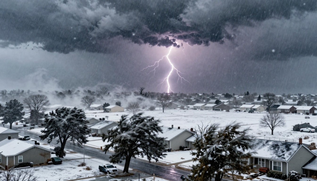
A fast-growing Mega Storm is set to surge out of the Rockies and spread across the central United States from Sunday into Monday. Forecasters expect extreme weather to build quickly, then fan out in several directions. This will make travel and daily routines rough.
At its peak, the mega storm could bring a mix of snow, thunderstorms, heavy rain, and sharp temperature drops. It will affect areas home to nearly 200 million people. This wide footprint can turn routine commutes into long delays and increase the risk of costly natural disasters.
In the Upper Midwest, blizzard conditions and strong winds may combine for near-whiteouts. Storms farther south and east could push damaging gusts and downpours. AccuWeather has warned the system could be one of the most disruptive U.S. weather events so far this year, with details shifting as the core strengthens.
Readers tracking early coverage can find more on the storm’s reach and risks in this mega storm forecast. Also, check out coast-to-coast alerts from nationwide storm warnings.
Mega Storm Key Takeaways
- A Mega Storm is expected to intensify quickly and expand across the central U.S. from Sunday into Monday.
- Impacts from the mega-storm may reach communities totaling nearly 200 million people, which is 3/4 of the U.S population.
- Extreme weather threats include blizzard conditions up north and severe thunderstorms farther south and east.
- High winds could worsen hazards, from difficult driving to scattered power outages.
- Rapid cooling behind the front may add another layer of risk tied to natural disasters, including ice and flash freezes.
- The forecast remains dynamic, so updates are likely as the storm’s track and intensity sharpen.
Forecast Overview: Rapidly Intensifying System to Bring Extreme Weather
A mega storm is quickly forming, affecting many areas. It shows how climate change can make the weather more extreme. It’s important to prepare early, before it’s too late.
Timeline and setup from Sunday into Monday across the central United States
The storm will grow stronger from Sunday to Monday. It will move from the central Plains to the Midwest and East. The weather will change fast as it comes.
Spring warmth will come first, then drop quickly as the cold air arrives. This change can cause different hazards at once. Some areas will see heavy snow, while others face severe storms.
This mega storm update warns of various dangers.
Why this storm could rank among the most impactful U.S. weather events of the year so far
AccuWeather says millions will be affected. The storm’s path will disrupt travel, school, and shipping. Small changes in the forecast can have big effects.
Preparing for disasters is harder when different areas face different risks. One area might deal with snow, while another faces flooding. Emergency plans need to account for widespread disruptions.
Potential “bomb cyclone” development and what it means for wind field expansion
AccuWeather’s Bernie Rayno says the storm could become a bomb cyclone. This means it will strengthen quickly. If so, its winds will spread, affecting more states.
Expansive winds can make the storm feel bigger. They can lower visibility, cause flooding, and damage power lines. This makes the storm’s impact wider than its track suggests.
Moisture sources fueling the storm: Pacific moisture tapping Gulf and Atlantic moisture
AccuWeather’s Matt Benz says the storm will get moisture from the Pacific, Gulf, and Atlantic. This mix can lead to different types of precipitation. It explains why forecast maps show many areas with heavy rain or snow.
Other basins are also active, and tropical influences are being watched. Recent news on Tropical Storm Alvin shows how warm water can fuel storms. For now, the focus is on staying prepared for severe storms and winter hazards.
Mega Storm Impacts by Region: Blizzard Conditions, Severe Storms, Heavy Rain, and Dangerous Winds
The Mega Storm is bringing extreme weather to a wide area of the U.S. It will cause different hazards in each region. Expect a wide wind field, sharp temperature drops, and heavy rain that can cause damage.
Even places that don’t get much snow will face travel problems. These conditions are similar to what you’d see in hurricanes.
Upper Midwest blizzard threat with whiteouts, heavy snow, and high winds
In the Upper Midwest, visibility is a big issue. Heavy snow and strong winds can cause sudden whiteouts. This is because Arctic air is moving in behind the storm.
With cold temperatures, even short times outside can be dangerous. AccuWeather says RealFeel® temperatures may drop near or below zero in the worst-hit areas. This adds to the extreme weather.
Snowfall corridor and totals: shovel-and-plow zone from the Dakotas to northern Michigan
A long area needing shovels and plows will go from the Dakotas to northern Michigan. Places in Wisconsin, Michigan, Iowa, northern Illinois, and southeastern Minnesota will face blowing snow. This makes roads hard to clear.
For more on the storm’s reach and timing, check this mid-March storm update. It shows how wind and rain will affect millions.
Highest accumulation zone: 1 to 3 feet possible from near Minneapolis and Green Bay to Michigan’s Upper Peninsula
The area with the most snow is a narrow band. Here, 1 to 3 feet of snow is possible from near Minneapolis and Green Bay to Michigan’s Upper Peninsula.
This amount of snow can break branches, strain roofs, and cause damage. It also makes it hard for crews to reach stranded drivers.
Chicago and southern Michigan: rain/wintry mix changing to snow
Closer to the rain-snow line, things get messy. Around Chicago and southern Michigan, rain or a mix will turn to snow as temperatures drop. This can leave a thin layer of ice before snow starts sticking.
Farther south and east, thunderstorms along the front can bring damaging winds, heavy rain, and hail. Tornadoes are also a risk. This severe threat can disrupt areas, such as hurricanes, even hundreds of miles away.
For more on the storm’s ice and travel impacts, including widespread shutdown risks, see this winter storm report.
Disruptions and Risks: Storm Damage, Power Outages, Travel Delays, and Emergency Response
Communities often face problems before the worst of a storm hits. Wind, poor visibility, and changing weather are big issues. That’s why getting ready for disasters is just as important as watching the forecast.
Expansive winds and storm damage risk
AccuWeather warns of strong winds affecting many states. These winds can knock down trees, remove shingles, and scatter debris. Drivers face dangers from crosswinds, even when roads seem clear.
As storms grow, warnings come faster. Local teams watch for hazards like downed lines and blocked roads.
Power outage risk: from tens of thousands to hundreds of thousands
Power outages could hit tens of thousands to hundreds of thousands. Wind and rain together can cause big problems. Recent blizzards in the Northeast showed how fast outages spread and how uneven repairs can be.
Getting ready for outages means having backup heat, charged devices, and food that doesn’t need a stove. Emergency teams focus on safety first, then on fixing damage.
Air travel impacts Sunday through Monday night
Flight delays and cancellations could reach thousands from Sunday to Monday night. Wind, storms, heavy rain, and low visibility will disrupt flights. Ground stops might occur when storms approach airports.
After the storm, recovery can take time. Past disruptions, such as shifting storm paths and cold air, are tracked in winter storm updates. Delays can spread to other airports for hours.
Major airport hubs that may be affected
AccuWeather says major airports like Denver, Chicago, and New York City might be hit. When these hubs slow down, smaller airports can get overwhelmed fast.
Schools and community plans might change, too. Families planning pickups or remote work can prepare ahead. Emergency teams also watch for heat and power risks in shelters and buildings; tips in extreme heatwave readiness help with outage planning.
- Road impacts: ponding in heavy downpours, sudden whiteouts in snow bands, and slick bridges.
- Home impacts: falling limbs, drifting snow at doors, and short-term loss of heat or internet.
- Public safety focus: fast severe storm warnings, clearing blocked routes, and restoring power safely.
Mega Storm Conclusion
The Mega Storm is expected to grow stronger from Sunday into Monday. It will then spread its impact as it moves east. Forecasters predict blizzard conditions in the Upper Midwest, severe thunderstorms, heavy rain, and strong winds in other areas.
With so many dangers at once, storm damage could quickly add up. This is a big worry for places that usually face only one threat at a time.
AccuWeather warns that nearly 200 million people could be affected. Officials are pushing for disaster preparedness until Monday night. Climate change makes it harder to predict rain, ice, and snow.
That’s why checking official forecasts and local alerts often is a good idea. This is as the storm’s path becomes clearer.
Bernie Rayno warns that the storm could become a bomb cyclone. This means a huge drop in pressure in just 24 hours. Such a drop can make winds stronger and snow travel more dangerous.
The main worries are power outages, flight delays, and bad road conditions. In the south, severe storms could bring damaging winds, hail, and a chance of tornadoes. This could increase the storm’s damage.
For a scary example of how fast water and infrastructure can become a crisis, look at the Whittier Narrows Dam flood-risk scenario. Weeks of extreme weather could lead to mass evacuations and test emergency plans.