Earthquake moves whole country: What You Need to Know
An unprecedented seismic event has occurred: an Earthquake moves whole contry. Discover important details and emergency preparedness tips now.

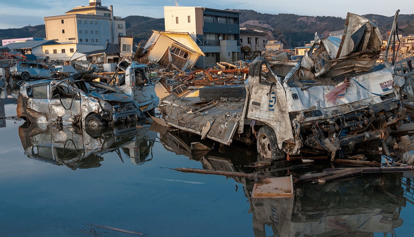
Earthquake moves whole country: New science offers a different perspective on Japan’s massive 2011, 9.0 earthquake. In the U.S. study, the results from Japan are surprising. On March 11, 2011, a massive earthquake happened. It showed something amazing: an earthquake can move a whole country, not just the area where it starts.
The quake had a magnitude of 9.0 and struck at 2:46 p.m. local time. Just 15 minutes later, Japan’s GPS network showed a big eastward shift. This suggested the earthquake’s effects went far beyond the coast.
The shift was tiny but permanent, about 5–6 millimeters. At first, some thought it was just a glitch. The movement seemed too big and too uniform for a typical earthquake.
But University of Chicago geophysicist Sunyoung Park didn’t give up. She compared GPS data with seismic records over the years. Park proved the country-wide motion was real. She said it shows a unique process that sensors in areas with fewer sensors might miss.
This is important in the U.S. too. Our country has big faults and deep basins, but we don’t always have enough sensors. When an earthquake leaves subtle marks everywhere, it changes how we prepare for disasters. It’s similar to what FEMA recommends in its earthquake preparedness guide.
Key Notes
- A 2011 seismic event in Japan produced evidence of an earthquake that moved the whole country, seen well beyond the main rupture area.
- The quake started at 2:46 p.m. local time, and the broad GPS shift appeared about 15 minutes later.
- The movement was permanent but tiny—about 5–6 millimeters—so it was easy to mistake it for erroneous data at first.
- University of Chicago researcher Sunyoung Park concluded the signal reflected a real, rare process.
- The finding raises questions for U.S. hazard monitoring, where sensor networks are less dense.
- Earthquakes can move an entire country, and the effects could complicate how damage and risk are interpreted after a major natural disaster.
What happened during Japan’s 2011 seismic event and why it matters now
On March 11, 2011, Japan faced a major crisis. The earthquake, tsunami, and nuclear emergency were all major news. But there was another motion that was difficult to notice.
For U.S. readers, the key point is that some movement occurred later and spread more widely than expected. This timing can make early damage assessment and disaster response planning tricky.
Timing and location: the March 11, 2011, magnitude 9.0 earthquake off northeast Japan
The magnitude 9.0 earthquake hit about 231 miles (372 kilometers) northeast of Tokyo. It was Japan’s strongest quake ever recorded.
The quake triggered a massive tsunami and a nuclear crisis, killing about 20,000 people. Scientific American reported on the country-wide impact.
GPS measurements: a near-uniform eastward shift across Hokkaido to Kyushu about 15 minutes after the mainshock
Minutes after the quake started, GPS stations across Japan recorded a different motion. They showed a uniform eastward shift from Hokkaido to Kyushu.
This shift happened about 15 minutes after the quake began. It didn’t match the first shaking and came before aftershocks. This timing is important for quick damage assessment.
Scale of movement: a permanent 5–6 millimeter displacement spread across roughly 1,800 miles of mainland Japan
The shift covered about 1,800 miles across Japan. Yet, it was only 5–6 millimeters and permanent.
University of Chicago’s Sunyoung Park said, “Basically, the whole of Japan moved nearly uniformly at the same time.” This small change over such a large area is difficult to spot without detailed geodetic coverage.
How does this phenomenon differ from typical earthquake damage patterns and localized ground rupture?
Most earthquakes cause localized deformation. Ground rupture and tearing tend to be near faults, making damage assessment easier.
Columbia University’s Goran Ekström noted that the 2011 event caused plates to slide under Japan by about 10 meters. The quake caused the shaking and a tsunami, moving Honshu east by about 20 cm. This phenomenon contrasts with the later uniform drift that affected early disaster response.
Earthquake moves whole country: the science behind the broad, country-long shift
Researchers in Japan made a surprising discovery in 2011. A wide, almost uniform push came after the main quake. They think seismic waves can travel deep and affect the surface.
Seismic waves traveling to Earth’s core and rebounding back to the crust
Park’s team found seismic waves that went deep into the mantle. They hit the “core” and bounced back up. The “core” is the outer core, a layer of liquid metal that reflects energy.
This bounce changes how we feel the quake. Instead of just shaking near the epicenter, it can spread far and wide.
Why scientists once thought core-bounced energy dissipated before returning to the surface
Many thought deep energy would fade before reaching the surface. But Park found it unusual and broad. He called it a “deep-diving wave triggering some kind of event,” which is very rare.
Vedran Lekić at the University of Maryland credits Japan’s detailed monitoring network. It helped spot this signal. He says similar signals might be missed elsewhere, even if they pass through.
Tectonic plate movement involved: interactions among the Pacific, Okhotsk, Philippine Sea, and Eurasian plates
The shift is due to complex tectonic plate movement. It involves the Pacific and Okhotsk plates and the boundary between the Philippine Sea and Eurasian plates.
This mix of plate interactions explains the broad motion. Small changes in timing and direction can have big effects when stress is high.
Fault line activity and triggering: how the main rupture may have primed broader movement along distant plate boundaries
Park believes the initial shaking set the stage for later fault line activity. The main rupture might have made it easier for energy to reactivate faults and move distant plate boundaries.
They considered other causes, like an undersea landslide. But it wouldn’t explain the wide shift. For U.S. readers, the Pacific Northwest is at risk due to fault-line activity and subsidence, as noted in the Pacific Northwest tsunami risk.
Geological impact, seismic hazard, and implications for disaster response in the United States
The Japanese findings show a greater geological impact than expected from a single rupture. For the United States, it’s not about panic but about better monitoring and planning. It also makes us think about disaster response when shaking isn’t the only effect after a big quake.
Why this is considered a new seismic hazard: minutes-later effects beyond aftershocks
Researchers like Professor Robert G. Park say policymakers might overlook seismic risk. A big earthquake can affect fault systems for many minutes after the main event, not just through aftershocks. Later-arriving waves can add stress far from the original rupture, even after the strongest shaking has passed.
Amanda Thomas of the University of California, Davis, has pointed out that large events can affect faults in unexpected ways minutes later. She notes that scientists don’t fully understand how faults work, and observations like these add to the puzzle. This uncertainty is important for emergency preparedness because timing and location can look finished before the system is truly quiet.
Predictability window: the roughly 15-minute round-trip travel time of deep-diving seismic waves
Aftershocks are difficult to predict, making them difficult to plan around in real time. But the core-bounced signal is tied to travel time: down and back, roughly 3,600 miles, in about 15 minutes. This creates a time-linked window that could be anticipated once a major quake is detected.
Reports suggest the energy was comparable to a magnitude 7.5 event, yet spread across a broad footprint. This spread would likely be felt less strongly than a typical 7.5, which concentrates energy in a single region. For U.S. agencies, the challenge is messaging: “less intense” does not mean “irrelevant,” even when systems are already strained.
Earthquake damage assessment challenges: separating core-wave impacts from mainshock and aftershock damage
Park has argued that any resulting harm would be very difficult to separate from damage caused by the mainshock and later aftershocks. This complicates earthquake damage assessment in the first hours, when officials are deciding where to send crews and how to prioritize lifelines. Mixed signals can blur the distinction between whether a cracked wall, a broken water main, or a derailed track was caused by the first wave of shaking or a later, subtler push.
This is where dense geodetic data and seismic records matter. Japan’s GPS coverage helped reveal small, widespread shifts that dense geodetic data and seismic records might otherwise miss. In the United States, similar network strength helps analysts tag what changed, when it changed, and how far the effect reached.
Emergency preparedness takeaways for US audiences: monitoring, alerts, and readiness for complex natural disasters
For U.S. readers, emergency preparedness works best when it assumes a sequence: main rupture, aftershocks, and possible minutes-later system-wide effects. Officials often stress alerts, redundancy, and clear routes because people make better choices when plans are simple. FEMA guidance and NOAA Weather Radio remain common tools, and local alert systems can fill gaps when cell networks are overloaded.
Teams that train together can move faster when the situation changes. Community programs such as CERT, local VOAD partners, and public works crews fit into the same disaster response picture, even as damage reports evolve. For practical steps on kits, evacuation planning, and staying informed, many readers turn to preparedness basics that translate well to earthquake scenarios.
- Keep a home kit with water, shelf-stable food, cash, and basic repair supplies like plastic sheeting and duct tape.
- Store a small car kit containing first aid supplies, a flashlight, extra batteries, and any needed medications.
- Plan for pets and for people who rely on medical devices, and keep key records in waterproof storage with a digital backup.
Earthquake moves the whole country: Conclusion
The March 11, 2011, earthquake in Japan taught us a big lesson. It showed how a massive quake can move a whole country. GPS records indicated that Japan moved a bit east about 15 minutes after the quake.
This movement was small but real. It was about 5–6 millimeters over 1,800 miles. This change was surprising to scientists.
What was surprising was not the shaking itself, but how the energy traveled. It was how the energy traveled. The energy went deep into the Earth’s core and then came back up, moving the surface.
This finding changed how scientists think about earthquakes. It showed that deep energy can affect the surface, even in a big quake.
In the United States, this lesson focuses on disaster preparedness. Big quakes can cause big effects right after they start. This short time can help responders act fast.
But it also makes it harder to assess damage. It shows we need to be ready for disasters to happen quickly. We need better monitoring and alerts.
Japan’s detailed networks helped scientists notice this. Vedran Lekić says we might miss this elsewhere. That’s why we need to be ready for disasters with modern science.
Recent reports on extreme hazards remind us of this. They show how fast disasters can happen. When the ground and weather change fast, we must be ready just as quickly.
For more on natural disaster impacts, check out this article.